 Land owned by Peacocks or their relatives is shown in blue. Click on the map to enlarge it.
First Settlers on Lots 1-13 of Concessions VIII and IX
The concession road ran between these two concessions (south part of 9 and north part of 8). The river was located to the East at about lot 13.
"Register of Free Grants under the Free Grant and Homestead Act of 1868
Macaulay was surveyed by John Ryan in 1857 and offered for location in 1861. Lots settled between 1861 and 1868 are not in this (Martin's) list, nor are any lots not settled under this Act."
However, I have taken lots 2 and 3 from the 1878 Atlas of Muskoka. Please note - there is no Lot 1 in Macaulay Twp.
(Information within quotation marks is taken from W.J. Martin's website. Click on above title to see it)
CONCESSION VIII............CONCESSION IX (north of VIII)
Lot Locatee....Location Date........................Lot Locatee.....Location Date
.2 R. Stinson pre 1869............2**Jas Cartwright-pre 1869
.3 no occupant........................3 J. Foster............................
.4 John Keall......8 Jun 1868.....4 John Foster....4 Jun 1868
.5 Jos.Cartwright 5 Apr 1870...5 Wm Devor.......6 Nov 1869
.6 John Goggin...20 Apr 1871....6 Wm Devor ......3 Jun 1869
.7 Wm Goggin Sr 22 Aug 1868...7 Wm Brown...14 Nov 1870
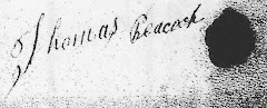
.8 Wm Goggin Jr..26 Oct 1868...8 Thos Peacock 5 Feb 1872
.9 Maggie Goggin..18 Feb1870...9 Alfred Hay....16 Apr 1870
10 James Taylor 14 Jan 1870...10 Wm Hay.........2 May 1870
11 Rob't May .........7 Nov 1870...11 Wm Hay........15 Nov 1870
12 David E. Lowe 9 Nov 1870...12 Marg Foster.23 Dec 1869
13 Thos Peacock 7 May 1872...13 Thos Peacock 23 Jan 1874
14 Thos Sterritt 23 May 1870...14 Jas Clerihue ...7 Oct 1871
**1878 Atlas Map shows the church on the south part of Lot 2 Concession 9, James Cartwright's land.


No comments:
Post a Comment