Bracebridge L.O.L. 218
This lodge was officially organized on December 2, 1868, but Orangemen had held meetings in the area before this time. There was an Orange Parade in Bracebridge as early as 1866. This view finds support in a special edition of the Bracebridge Gazette, published in 1906. The writer describes the hamlet as it appeared about 1866 including the fact that "crossing the bridge the first building to the right was the Orange Hall...." Whatever the case, L.O.L. 218 is among the oldest functioning community institutions. It ranks with the postal service [1864], education [1866], religion [1861], and the municipality itself [1868].
The first Orange Hall was a real community centre in the pioneer days. Methodists and Anglicans used it for church services, socials and concerts. The hall was a meeting place for school board, municipal council and many other meetings. The inaugral session of the Village of Bracebridge Council met there on January 19, 1875. The first issue of the Muskoka Herald was published on April 11, 1878 in a room at the back of the Orange Hall. The Bracebridge lodge was a bastion of Orange strength and influence in Muskoka. Its members were numerous [since 1882, 525 men have joined; before that the records are incomplete] and noteworthy.
Thomas McMurray the first Reeve of the United Townships of Draper, Macaulay, Stephenson and Ryde, David Edgar Bastedo and George W. Boyer were all associated with newspaper publication. The first District Judge of Muskoka, W.C. Mahaffy [whose tenure of duty ran from 1886 to 1912] and William Lowe, the Inspector of Colonization Roads for Muskoka both became members of L.O.L. 218 in 1911. James Boyer, who was village clerk from 1875 until 1889, began his active Orange career in Bracebridge in 1876, At times, all members of the Macaulay Township Council were Orangemen, many associated with the Bracebridge Lodge.
The lodge could even claim priests among its membership! Walter H. Frith [1915] and Robert H. Loosemore [1936] of the Society of St. John the Evangelist [S.S.J.E.] were active Orangemen. A silk Union Jack and a leather-bound bible are still in use by the lodge, gifts from Father Frith. Captain Cornthwaite of the Salvation Army and Reverend F.L. Brown of the Methodist Church were active in the lodge.
Some of the well known personalities of the town who were members included T.J. and Wilbur Anderson [merchants], Harry Boyer [monument works], George and Frank Crozier [merchants], William R. Fisher [florist], Alfred Hunt [banker], Wilbert Richards [town clerk], William J. and W.W. White [undertakers]. None ever came close to the devotion of James Clark of Macaulay Township. Born on July 12, 1839 in County Tyrone, Ireland he joined the Orange Society on his 17th birthday and never missed a celebration of the Battle of the Boyne[until?]1932. His obiturary claimed that his record of attendance at Twelfth celebrations was probably unequalled in Ontario.
Clark's life was one of community interest. He was a hunter of big game and founded the Spring Lake Hunt Camp. He was councillor in Macaulay Township for 30 years, postmaster of Monsell for 42 years and laid the cornerstone for the Purbrook Anglican Church and served as Church Warden for many years. Men of professional influence joined the lodge as well. The first medical doctor in town, J.N. Byers was a member, and in the 1890's, Dr. R.N. Topp was a member and held the position of lodge physician. He was paid $55.00 a year to physically examine every candidate for membership.
Gary Denniss
(Click on title for source website)
Showing posts with label Muskoka History. Show all posts
Showing posts with label Muskoka History. Show all posts
Saturday, July 24, 2010
Thursday, July 9, 2009
Muskoka History - Wikipedia
European arrival
Largely unsettled until the late 1760s, the European presence in the region was largely limited to seasonal fur trapping, and no significant trading settlements were established. Canadian government interest increased following the American Revolution, when fearing invasion from its new neighbor to the south, the government began exploring the region in hopes of finding travel lanes between Lake Ontario and Georgian Bay.
In 1826 Lieutenant Henry Briscoe became the first white man known to have crossed the middle of Muskoka. The great explorer, David Thompson, drew the first maps of the area in 1837 and possibly camped near present day Beaumaris. He was 67 years old when the government sent him to investigate the area. His route from Georgian Bay was through Go Home Lake, across Lake Muskoka, up the south branch of Muskoka River and across the Lake of Bays. He eventually reached Madawaska and continued on to the Ottawa River.
Canada experienced heavy European immigration in the mid 1800's, especially from Ireland which experienced famine in the 1840s. As the land south of the Severn was settled, the government planned to open the Muskoka region further north to settlement.
Logging licenses were issued in 1866 which opened Monck Township to logging. The lumber industry expanded rapidly denuding huge tracts of the area, but also prompting the development of road and water transportation. The railroad pushed north to support the industry, reaching Gravenhurst in 1875 and Bracebridge in 1885. Road transportation took the form of the Muskoka Colonization Road, begun in 1858 and reaching Bracebridge in 1861. The road was roughly hewn from the woods and was of corduroy construction, meaning logs were placed perpendicular to the route of travel to keep carriages from sinking in the mud and swamps. Needless to say this made for extremely rugged travel.
The lumbering industry spawned a number of ancillary developments, including as mentioned, transport, but also settlements began springing up to supply the workers and Bracebridge, (formerly North Falls) saw some leather tanning businesses develop. Tanners used the bark from lumber to tan hides thereby using what otherwise would be a waste product.
The passage of the Free Grants and Homestead Act of 1868 opened the era of widespread settlement in Muskoka. Settlers could receive free land if they agreed to clear the land, have at least 15 acres (61,000 m2) under cultivation, and build a 16 by 20-foot (6.1 m) house.
Settlers under the Homestead Act, however, found the going hard. Clearing 15 acres of dense forest is a huge task, and once the land was clear, they were greeted with Muskoka's ubiquitous rocks which themselves had to be cleared. The soil in the region turned out to be poorly suited to farming consisting largely of a dense clay. As news of the difficult conditions spread back to the south it looked as though development in Muskoka might falter but for a fortuitous development.
In a time when the railroads had not yet arrived and road travel was notoriously unreliable and uncomfortable, the transportation king was the steamship. Once a land connection was made to the southern part of the lake in Gravenhurst the logging companies could harvest trees along the entire lakefront with relative ease, so long as they had the means of powering the harvest back to the sawmills in Gravenhurst.
1872 Simcoe Gazetteer - Falkenburg
FALKENBURG - A post-office in Macaulay Township, lot 2, 10th con., 6 miles from Bracebridge, and 68 from Barrie. The neighborhood was first settled in 1862 by Edwin Griffin, Sidney Tibbs, and Samuel Holditch. The Muskoka River, in the vicinity, provides almost unlimited manufacturing power.
Brown, Wm., plasterer.......................} Loughead, Robert, farmer
Clarke, Rev. John, Wesleyan ...................} Loughead, Samuel, farmer
Earnshaw, Joshua, farmer.......................} Low, David, farmer
Forsyth, John, farmer................... } McNee, James, farmer
Galloway, David, shoemaker................... } Miller, Robt., carpenter
Hamilton, A., farmer................................ } Moore, Francis, farmer
Holditch, Samuel, farmer......................... } Moore, Matthias, P.M.,
Jack, John, farmer.................................... } farmer
Jack, William, farmer ...............................} Palmer, John, farmer
Jackson, John, blacksmith....................... } Schafer, Samuel, farmer
Kirby, Nathaniel, farmer.......................... } Stinson, Thomas, farmer
Levier, Chas., farmer................................. } Stinson, Robert, farmer
Levier, James, farmer............................... }
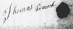
The William Brown above is probably the father-in-law of Catherine Peacock, Mrs. Wm Brown, Jr. He is shown as a stone mason in the census records ,and the son as a farmer.
Brown, Wm., plasterer.......................} Loughead, Robert, farmer
Clarke, Rev. John, Wesleyan ...................} Loughead, Samuel, farmer
Earnshaw, Joshua, farmer.......................} Low, David, farmer
Forsyth, John, farmer................... } McNee, James, farmer
Galloway, David, shoemaker................... } Miller, Robt., carpenter
Hamilton, A., farmer................................ } Moore, Francis, farmer
Holditch, Samuel, farmer......................... } Moore, Matthias, P.M.,
Jack, John, farmer.................................... } farmer
Jack, William, farmer ...............................} Palmer, John, farmer
Jackson, John, blacksmith....................... } Schafer, Samuel, farmer
Kirby, Nathaniel, farmer.......................... } Stinson, Thomas, farmer
Levier, Chas., farmer................................. } Stinson, Robert, farmer
Levier, James, farmer............................... }
The William Brown above is probably the father-in-law of Catherine Peacock, Mrs. Wm Brown, Jr. He is shown as a stone mason in the census records ,and the son as a farmer.
8th and 9th Concession of Macaulay
 Land owned by Peacocks or their relatives is shown in blue. Click on the map to enlarge it.
First Settlers on Lots 1-13 of Concessions VIII and IX
The concession road ran between these two concessions (south part of 9 and north part of 8). The river was located to the East at about lot 13.
"Register of Free Grants under the Free Grant and Homestead Act of 1868
Macaulay was surveyed by John Ryan in 1857 and offered for location in 1861. Lots settled between 1861 and 1868 are not in this (Martin's) list, nor are any lots not settled under this Act."
However, I have taken lots 2 and 3 from the 1878 Atlas of Muskoka. Please note - there is no Lot 1 in Macaulay Twp.
(Information within quotation marks is taken from W.J. Martin's website. Click on above title to see it)
CONCESSION VIII............CONCESSION IX (north of VIII)
Lot Locatee....Location Date........................Lot Locatee.....Location Date
.2 R. Stinson pre 1869............2**Jas Cartwright-pre 1869
.3 no occupant........................3 J. Foster............................
.4 John Keall......8 Jun 1868.....4 John Foster....4 Jun 1868
.5 Jos.Cartwright 5 Apr 1870...5 Wm Devor.......6 Nov 1869
.6 John Goggin...20 Apr 1871....6 Wm Devor ......3 Jun 1869
.7 Wm Goggin Sr 22 Aug 1868...7 Wm Brown...14 Nov 1870
.8 Wm Goggin Jr..26 Oct 1868...8 Thos Peacock 5 Feb 1872
.9 Maggie Goggin..18 Feb1870...9 Alfred Hay....16 Apr 1870
10 James Taylor 14 Jan 1870...10 Wm Hay.........2 May 1870
11 Rob't May .........7 Nov 1870...11 Wm Hay........15 Nov 1870
12 David E. Lowe 9 Nov 1870...12 Marg Foster.23 Dec 1869
13 Thos Peacock 7 May 1872...13 Thos Peacock 23 Jan 1874
14 Thos Sterritt 23 May 1870...14 Jas Clerihue ...7 Oct 1871
**1878 Atlas Map shows the church on the south part of Lot 2 Concession 9, James Cartwright's land.
Sunday, August 24, 2008
The Night the Mice Danced
The Night the Mice Danced the Quadrille: Five Years in the
Backwoods 1875-1879 (Boston Mills Press) is a Muskoka
local history book written by a Thomas Osborne in 1934.
Osborne relates the events of his time spent in Muskoka as a
young man when the area was first being settled.
Thomas Osborne worked for Fawcett’s store at Port Sydney
and one of his duties was to travel by wagon to Bracebridge to
pick up provisions. On one of these trips a young man named
James Peacock hailed him from the side of the road and asked
for a lift with his luggage to Bracebridge. Osborne and Peacock
had quite a chat, as Thomas had previously seen James in a fight
in the Kensington section of Philadelphia. He states that the
match took place on a lot at Amber and Adams Streets.
Peacock’s opponent was named Devine.
James Peacock told Thomas Osborne that he had been staying
with an uncle in Muskoka during the previous year. It is probable
that the uncle was Thomas Peacock who would have been living on
his free grant land in the mid 1870s which was located south of Port
Sydney and north of Bracebridge.
There are three James Peacock’s in the 1880 Federal Census of
Pennsylvania:
James Peacock, 30, b. PA, Carpenter, parents born in Ireland
– Freeland, Luzerne, PA
- (wife Hannah, sister Mary Peacock, 18, dressmaker)
James Peacock, 35, b. PA living with a young Smith couple in
Philadelphia.
James Peacock, 26, b. PA, farmer (parents born Ireland)
with wife Lizzie and baby William J.
- in Cecil, Washington, Pennsylvania.
This anecdote is significant in that it reveals that there was
movement between the US and Canada, even from the remote
areas of settlement. And because Thomas Peacock’s eldest
son Frederick married in Philadelphia.
Wednesday, August 6, 2008
History of Falkenburg, Muskoka
This article appears on a website devoted to abandoned
communities in Ontario. Click on the heading to see the website
and some old photos of Falkenburg.
FALKENBURG (Also known as Falconburg)
Falkenburg was another settlement which popped up along the
Colonization Roads of Ontario. In this case it was the Muskoka
Road which the Ontario Government decided to construct in the
hopes of luring settlers to the area.
Beginning in 1859, teams of men were employed to build the road.
They chose to use portable sawmills while planking the road as it
was easier than moving the lumber as they progressed. The
Muskoka Road was approximately 16 feet wide with one side built
on an incline to allow water to drain off. Constructing a road out of
lumber posed problems, however. When bush fires occurred, any
burning trees that fell on the road resulted in igniting the road
planks. Also, the stagecoach services running along the road would
cut the wood with their sharp horseshoes. When the Muskoka Road
was completed, it would run 210 km to the city of North Bay.
Falkenburg was one of the first settlements to lure residents from
overseas looking to settle along the Muskoka Road. Being at the
southern end of the road, Falkenburg was seen as a favorable place
to live rather than travel northward. Matthias Moore was one such
immigrant to arrive from overseas and settle in Falkenburg. Moore
wasted no time in constructing a saw and shingle mill to provide
lumber for the ongoing construction.
The post office opened in 1863 with 26 year old William Holditch
being the first postmaster. Moore took over in 1872 until his death
in 1893 when Robert George would take over.
Stagecoaches were constantly running passengers to Bracebridge.
Two hotels were built to accomodate visitors along with a church,
blacksmith and general store.
The railway soon appeared out of the forest but a few kilometres
south of Falkenburg. There, a train station was built under the
name of Falkenburg Station. With more passengers choosing to
use the railway rather than stagecoach, Falkenburg's importance
began to diminish.
Today you will find remains of an old mill on the western side of
the town. It can be found at the end of a dead-end road, where
the Moore cemetery also happens to be.
Falkenburg is rather easy to find. It is on Muskoka Road 4 which
parallels Highway 11. As you drive north from Bracebridge along
Muskoka Road 4, you will pass Falkenburg Station. After you pass
the second set of railway tracks, Falkenburg will be on the eastern
side (a right hand turn).
Sunday, August 3, 2008
Greener Fields - Muskoka District
The following article was taken from the Muskoka
Parry Sound Genealogy GroupWebsite.
Click on the title above to see the original.
History of Muskoka District
This article first appeared in the November 1985 newsletter,
Volume 1 - Number 2
Beginning in the late 1840's, the Ontario government gradually
implemented a policy of northern expansion in Canada West.
As part of this policy, Muskoka was surveyed and made accessible
during the next two decades.
In 1850, a treaty was signed between the Honorable B. Robinson
and 36 chiefs of the Ojibway Nation ceding to the government
the parcel of land northwest of Penetanguishine to Sault Saint
Marie and eastward to the Ottawa River. In 1852 a resolution
was introduced urging implementation of a free land grant policy.
Despite opposition and reports that "the country was unfit as a
whole for agricultural purposes" in 1857 Muskoka and Macaulay
Townships were surveyed. The following year the first Muskoka
road was surveyed from Washago to Muskoka Falls and
settlement was underway.
Settlement was slow prior to the passing of the Free Grant and
Homestead Act of 1868. The obligations of the settlers in this act
were "to clear and have under cultivation at least 15 acres, two acres
of which were to be cleared annually during the 5 years following the
date of location; to build a house at least 16'x20' and to have actually
and continually resided upon the land for 5 years after date of location."
Each settler over 18 years of age could receive 100 acres or with a
family, 200 acres. (The act also applied to the townships of Parry Sound
District). All applications were to made to Charles W. Lount, Crown
Land Agent in Bracebridge.
A strong campaign was carried out to attract settlers. In the late
1860's posters and pamphlets were distributed in Canada, Britain
and several European countries. By 1871 the population of Muskoka
was 6,000. By 1881 the population increased to 13,000.
Subscribe to:
Posts (Atom)