Showing posts with label Peacock Records Ireland. Show all posts

Monday, April 29, 2013

From ANTRIM or DERRY County?


When I first began researching the Peacocks in Ireland, the information I had was from John Peacock's marriage registration.  It stated that he was born in Derry.  Some years later when I contacted members from the Hugh Peacock line, they said they were from Antrim.  The death certificate of Thomas' wife, Sarah, has her birthplace as Antrim and John Peacock's obituary says Antrim.  So which is it?

Look at the map above.  In the top right of the county of Londonderry, you will see the Barony of Coleraine.  Just across the border in Antrim County, there is a little area called the N.E. Liberties of Coleraine.  The part of the parish of Ballyrashane which falls in the County of Antrim is in this little part.

It would seem that the confusion stems from the parish of Ballyrashane being located in both Derry County and Antrim County.  Without knowing exactly where each family member was born, it is impossible to know what county they belonged to.  Hopefully, we will find some church records at some time in the future.

Saturday, April 6, 2013

Knocknakeeragh, Ballyrashane - Griffith's Valuation 1848-64

Book 14A - The earliest date would be 1848 - click to enlarge
Book 14B - The latest date would be 1864 - click to enlarge

These photos are the original GRIFFITH'S VALUATION books now available on-line on the PRONI website.  The published version of 14A is available on ancestry.com.

Thomas Peacock has disappeared on the second page and does not appear in any other community in Ballyrashane.  It is suspected that this is our Thomas. He was probably the eldest son and was able to secure land.  However, the man we suspect was Thomas' brother, Hugh, left Ireland as a teenager and married in Toronto.  He was probably a younger or the youngest son with no hope of having his own land in Ballyrashane.  Many people from this parish had previously emigrated and continued to emigrate to America.

Saturday, March 19, 2011

Ballyrashane Ordnance Survey Map

Ordnance Survey Map (1830 or 1860?) of central part of Parish of Ballyrashane in the County of Derry. Click on title for source.


Friday, March 18, 2011

Ballyrashane -1837

from Lewis Topographical Dictionary, 1837 (click on title)

BALLYRASHANE, or ST. JOHN'S-TOWN, a parish, partly in the barony of LOWER DUNLUCE, county of ANTRlM, but chiefly in the north-east liberties of COLERAINE county of LONDONDERRY, and province of ULSTER, 3 miles (N.E.) from Coleraine; containing 2851 inhabitants.

This parish is situated on the road from Coleraine to Ballycastle, and comprises, according tothe Ordnance survey, 6360 3/4 statute acres, of which 2689 are in the county of Antrim, and the remainder in the county of Londonderry. The greater portion of the land is fertile and in a high state of cultivation; wheat and barley have been introduced since the year 1829, and are raised with great success. There are detached portions of bog, affording a good supply of fuel. Vast quantities of basalt are raised; and in a geological point of view the parish is very interesting, containing beautiful specimens of amorphous, columnar, and divaricated basalt, which are found here in all their varieties, accompanied with chalcedony, opal, zeolite, and other fossils; it abounds also with botanical specimens of considerable interest.

Brookhall, the seat of S. Boyce, Esq., is in this parish.

The inhabitants are principally employed in the weaving of linen cloth; and there are some paper-mills for brown and fancy papers, affording employment to about 80 persons.

The living is a rectory, in the diocese of Connor, and in the patronage of the Bishop: the tithes amount to £850. The church is a plain small edifice, in the later English style, erected by aid of a grant of £900 from the late Board of First Fruits, in 1826. The glebe-house, nearly adjoining it, was built in 1828: there is no glebe.

In the Roman Catholic divisions the parish forms part of the union or district of Coleraine.

There are two places of worship for Presbyterians in connection with the Synod of Ulster; one at Kirkstown of the first class, and the other at Ballywatt of the third class.

The male and female parochial schools at Lisnarick are supported by the rector, who also contributes annually to the support of a school at Ballyrack; at Ballyvelton is also a school, and there are two private pay schools and two Sunday schools.

At Revellagh are the ruins of a castle and fort. There are also some extensive artificial caverns at Ballyvarten, Island Effrick, and Ballynock; the first has four rooms or cells, 5 feet high and 2 1/2 feet wide, having the sides formed of unhewn stones and the roof of large flat stones.

Londonderry Census - 1831

Map: Sketch of the townlands in the Parish of Ballyrashane in the County of Derry. Click on title to see source of map. The yellow horizontal line is the road.

BALLYRASHANE Parish, DERRY
The townlands in Derry are:
*Articrunnagh, Ballindreen, *Ballynag, Ballyvelton, Ballyversal, Cloyfin, Glebe,
*Gorticloughan, Islandeffrick, Kirkistown, Knocknekeeragh, Lisnagalt, Liswatty.

BALLYRASHANE Parish, ANTRIM
The townlands in Antrim are:
Ballywatt, Bushmills, Windyhall


Below: 1831 Census - Source - LDS Library - Searched by S.L. Bowyer

Vol. 2 - Parish of Aughadowry, Barony of Half Coleraine
Some Millers, some Smyths, no Peacocks

Vol. 4 - Parish of Dunboe, Barony of Coleraine
Mary Given, 10 Blakes, 2 males, 1 female, Presb.
Thomas Given, 11 Blakes, 2 males, 4 females, Presb.

Vol. 7 - Parish of Macasquin, Barony of Half Coleraine
3 Smith families - 2 Davids and 1 Michael

Vol. 9 - Parish of Ballyrashane in Liberties of Part of Coleraine
(Remainder of the parish is in Barony of Dunless, Antrim Co.)
p. 1 - Robert Peacock, 4 Ballyversal, 4 males, 4 females, Presb.
p. 4 - Mary Peacock, 9 S. Crimagh, 3 females, Presb.

...... - Neal Peacock, 20 S. Crimagh, 5 males, 3 females, Presb.
...... - Hugh Peacock, 21 S. Crimagh, 3 males, 1 female, Presb.
...... - William Peacock, 25 S. Crimagh, 4 males, 3 females, Presb.
p. 3 - James Smith, 4 Crimagh, 3 males, 3 females, Presb.
p. 7 - Neal Peacock, 24 Clougham, 2 males, 2 females, Presb.
p. 10 - Wm Smyth, 22 Liswatty, 2 males, 1 female, Presb.
........ - Matthew Smith, 9 Ballymagy, 3 males, 7 females, Presb.
p. 13 - Simmon Smith, 19 Govey(?)sflush, 1 males, 1 female

Vol. 10 - Grange of Ballyrashane - Liberties of Coleraine
James Peacock, 24 Lougham, 5 males, 2 females, Presb.


Vol. 11 Parish of Ballyaughran, Liberties of Coleraine
p. 3 William Smith, 1 Island Faserly, 4 males, 4 females, 1 male servant,
Presb.

Monday, June 21, 2010

PEACOCKS of Ballyrashane, Ulster


Double click on map to enlarge it. In pink, you will see the area called Cloyfin. This townland can be seen on the modern map of Ulster which was posted previously.
*
The orange line encircles the townlands of the parish of Ballyrashane that are within the county of Londonderry. To the right, several townlands which fall within the same parish but in the county of Antrim are highlighted in yellow.

Peacocks in Derry: Ballyrashane Parish
(Source: Griffiths Valuation - 1848-1862)

James Peacock................... Kirkistown, Ballyrashane
Mary Peacock......................Kirkistown, Ballyrashane
Margaret Peacock, Articrunaght South, Ballyrashane
Samuel Peacock.... Articrunaght South, Ballyrashane
Thomas Peacock........Knocknakeeragh, Ballyrashane

Monday, July 27, 2009

Thomas PEACOCK, Ballyrashane

Griffith’s Valuation:
Fergusons of County Londonderry

July 16, 1859 Ballyrashane, County Derry

Occupier.........................Lessor.......................Townland............Parish
Benjamin Stirling...........James Ferguson.....Articrunaght..N. Ballyrashane
William Ferguson..........Samuel Laurence....Articrunaght..N. Ballyrashane
Joseph Anderson..........William Ferguson....Articrunaght, N. Ballyrashane
Mary Jane Ferguson.....Samuel Laurence....Articrunaght,..S. Ballyrashane
Benjamin Stirling..........James Ferguson......Articrunaght,.. S. Ballyrashane
Andrew Ferguson.........Mrs. Boyle................Knocknakeeragh, Ballyrashane
And.Ferguson/John Simpson...Mrs. Boyle...Knocknakeeragh, Ballyrashane
James M'Vetrick.........Andrew Ferguson......Knocknakeeragh, Ballyrashane
Thomas Peacock..Andrew Ferguson.Knocknakeeragh, Ballyrashane

http://freepages.genealogy.rootsweb.ancestry.com/~colin/FergusonsOfIreland/Derry/Griffiths.htm


THOMAS PEACOCK
Ballyrashane, CountyLondonderry;
Poor Law Union: Coleraine;
DED: Knockantern.

VAL/12B/30/14A-F.

BOOK 14A – 1860-63.

PLOT - NAME -Immed.Lessor - Descr. Of Holding -Ttl

9j-Thomas Peacock-Andrew Ferguson-House...........10s

BOOK 14B – 1864-80.

9j.........(Thomas Peacock).........Andrew Ferguson
4A+B.....James Stirling...............Andrew Ferguson
9j...........James Stirling...............Andrew Ferguson

(This book was a nightmare to transcribe. Thomas is stroked out of book 14B, and his name is not replaced. He is not listed anywhere else in this book. The holding of 9j is transferred to beside holding 4A+B, and all these are now rented to James Stirling. The enumerator amends this in red pen, dated 1876. Again, this is when he notes the change, not when the change actually happens. )


BOOK 14C – F
The rest of the books state that holding 9j is with 4A+B, and is rented out now to John, Thomas and Andrew Stirling. No further sign of Thomas or any other Peacock in this townland.

Again, this is inconclusive as we know Thomas has lost the holding by 1876, and we see no further sign of him in this townland. Could he have moved to another townland or emigrated.


-Researched by Sandie B./ 2008

Friday, July 24, 2009

Provinces of Ireland and Northern Ireland

The Four Provinces
In ancient times, Ireland was divided into provinces, each ruled by a King. These provinces were dynamic and their borders changed all the time. Today, when Irish talk about the provinces of Ireland, they mean Leinster, Ulster, Munster and Connaught. However, historically there were more than 4 provinces: others included Breifne [between Ulster and Connaught], Oriel [around county Armagh] and Meath [the northern half of Leinster]. The map above shows the 4 provinces of Ireland as they currently exist. The borders of these provinces coincide exactly with the county boundaries

Click on title for more information

Modern Map of Derry and Antrim

***************Bartholomew Map of NE Ireland***********
Click on Map to Enlarge
The border between Derry to the west and Antrim to the East is shown with a gray vertical line between Port Rush and Lough Neagh. The River Bann is west of this line.

Note on Land Divisions in Ireland
Province
The oldest and largest land unit in Ireland is the Province, dating back into pre-history and early historic times. There were originally five Provinces in Ireland, with provincial ‘overkings’ who were supported by the kings of the smaller local kingdoms within. By the 17th century, the number of Provinces was reduced to four – Ulster in the north, Leinster in the east, Connaught in the west and Munster in the south.Present day Northern Ireland (sometimes referred to as Ulster) comprises six of the nine counties that make up the Province of Ulster, with counties Cavan, Donegal and Monaghan now lying within the Republic of Ireland.
County
The county is the territorial equivalent to the English shire. It was created by the English administration in Ireland as the major subdivision of an Irish province in the years following the Anglo-Norman invasion of Ireland. The county system as it is today was extensively used in the great 17th century land surveys such as the Civil Survey, Petty’s Down Survey and the Books of Survey and Distribution.
-The county was the principal unit of administration for justice in Ireland - for the courts of Quarter Sessions and Assizes. The modern system of local government introduced in Ireland under the 1898 Local Government Act also used the county as its administrative unit. This was not abolished in Northern Ireland until 1972, when new district council areas were created.
Barony
The barony is now an obsolete administrative unit that is mid-way in size between a county and a parish. It derived, at least in part, from the district of an Irish chieftain who held his land from the kings of a Province. The system of bringing Irish local kingdoms into baronies began in the medieval period but did not extend to the whole of Ulster until the early 17th century. By this time the barony was being used for taxation and administrative purposes and will be found in land, tax and other government records. Even the 19th century valuation books and census returns all record the barony. Large baronies were subdivided until there were 58 baronies in the area that comprises the present day Northern Ireland.
Parishes
-Civil parishes
The parish was once an ecclesiastical unit of territory based on early Christian and monastic settlements. It was then adopted as a civil administrative area. Over time, some civil and ecclesiastical boundaries came to vary.
-Church parishes
The boundaries of Church of Ireland parishes largely coincide with those of civil parishes and are called by the same name. In contrast Roman Catholic parishes, though originally based on what became the civil parish, frequently do not correspond with the names or boundaries of civil parishes. The boundaries of present day civil parishes were not finally demarcated until the mid 19th century - until then, it was not uncommon to find parishes being subdivided to form new parishes, or townlands being moved from one parish to another. Both civil parishes and Roman Catholic parishes can cross county and barony boundaries. The parish was frequently used for administrative purposes in the 19th century, for example, in the tithe applotment survey, the census returns and the valuation records. In Northern Ireland there are 268 parishes.
Townland
The townland is an ancient unit, dating back to pre-Norman times. It is the smallest administrative division throughout the island of Ireland that is still in use. The spelling of townland names is subject to considerable variation, due largely to the difficulties of representing the pronunciation of Irish language names in English spelling. They were also the principal division in major land valuations, surveys and census enumerations such as the tithe applotment books and Griffith’s valuation. The significance of the townland today is to help identify small local rural areas.

Griffith's Valuation

"In order to produce the accurate information necessary for local taxation, the Tenement Act of 1842 provided for a uniform valuation of all property in Ireland, to be based on the productive capacity of land and the potential rent of buildings. The man appointed Commissioner of Valuation was Richard Griffith, a Dublin geologist, and the results of his great survey, the Primary Valuation of Ireland, were published between 1848 and 1864." (http://www.failteromhat.com/)

(We don't have the town name where our Peacock ancestors originated. Marriage and death records in Canada mention County Antrim twice and County Derry once. Other records just state Ireland. )

I have 'bolded' the names that are in our Peacock families.

Peacocks in Antrim:
*Chesnut, Park, Armoy
Alice, Carnanee, Ballylinny
*Samuel, Roseyards, Ballymoney
Anne, Whiteabbey, Carnmoney
Robert, Moylarg, Craigs
William, Loughmagarry, Craigs (NW of Ballymena)
Mary, Loughmagarry, Craigs
James, Loghmagarry, Craigs
William, Tullaghgarley, Craigs
Samuel, Carnlea, Kirkinriola (NE of Ballymena)
Archibald. Craigywarren, Kirkinriola
Stephen, Craigywarren, Kirkinriola
Henry, Crosshill, Killead
Alexander, Ballyrobin, Killead
Ellen, Ballynadrentagh, Killead
Henry, Ballynadrentagh, Killead
*Hugh, Drumnafivey, Loughguile (E of Ballymoney, S of Armoy)
James, Lisnacrogher, Skerry
Agnes, (Peacocke with an ‘e’)St. Ann’s Ward,Townparks Haldane Street, Shankill
Rebecca, Cromac, Townparks SussexPlace, Shankill
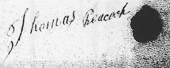
* thought to be three sons of Thomas died 1834

Peacocks in Derry:
William, Highland Row,Coleraine, Coleraine
Samuel, Gateside, Coleraine
John, Gateside, Coleraine
John, Blagh, Coleraine
John Knockantern, Coleraine

Francis, (with an e)Brooke St.,Coleraine, Coleraine
Wiliam, Killure,Macosquin
Thomas, Ballymacilcurr, Maghera
Thomas, (with an e)Ballymacilcurr, Maghera
Oliver, Charity St.,Magherafelt, Magherafelt,
John, Charity St.,Magherafelt, Magherafelt, (SW of Ballymena)
James, Kirkistown, Ballyrashane
Mary, Kirkistown, Ballyrashane
Margaret, Articrunaght South, Ballyrashane
Samuel, Articrunaght South, Ballyrashane
**Thomas, Knocknakeeragh, Ballyrashane

**followed up in land records - seen as a strong possibility

Griffith's Valuation 1848–1864

Primary Valuation of Tenements 1848–1864
(click title for source of information)

Of the Irish records available to the genealogical researcher, one of the most useful is the Primary Valuation of Tenements carried out between 1848 and 1864. This listed every property holder in the country, with details of their houses, outbuildings, fields and gardens. The purpose of the vast survey was financial; to estimate the net annual value of every property in Ireland and determine the local taxation rate payable by each householder.

The survey is commonly known as Griffith's Valuation after Sir Richard Griffith who oversaw the work. Griffith, by training an engineer and geologist, was an administrator of exceptional energy.....The Valuation was compiled on a barony basis and further subdivided according to townlands, civil parishes and the electoral divisions of Poor Law Unions.

In the printed version the first column heading is number and letters of reference to map which refers to the location of the tenement on the 6’’ to the mile townland maps. Under the column description of tenement, land and buildings are included, and under the column net annual value, the annual rent expected, including maintenance and taxes and excluding the tithe rent, is given.The basis of Griffith's survey is the townland, the smallest unit of civil administration in the country. Ireland is the only country to have townlands; their origin dates back at least to Anglo-Norman times.

Within each townland is listed the full name of each person holding land with the exact area given in acres, rod, and perches. One rod is equal to a quarter acre which is equal to forty perches. People with land in more than one townland are listed in each and the townlands are arranged alphabetically within their civil parish. Parishes are arranged within their baronies, and baronies are arranged by county.

Of course, with the passage of time, landowners died or bought and sold properties, even during the decade and a half that the survey lasted. In order to keep up with these changes the taxation officials kept manuscript copies of the original valuation books and entered new details as appropriate. They used different colors of ink and tried to preserve them as neatly as possible. Inevitably the books became rather confusing and difficult to read. When the finished books were published the information was as up to date as possible while the old "cancelled" books for individual districts were kept together in bound volumes in the Valuation Office.

Griffith’s Valuation provides detailed information about land tenure, names of lessors and occupiers, their land and buildings. It records the occupier’s name, the extent of his holding, and the immediate landlord who is not necessarily the owner. However, one must bear in mind that it does not carry names of married sons or daughters for example, who may also occupy the dwelling.

The information on towns is equally important, as the individual tenements were arranged according to streets. It is the only general assessment of land values in Ireland.The Valuation represents an impressive undertaking in terms of land survey and the amassing of valuable social and economic data. Its value to those seeking information on their ancestors is obvious, although it goes further by providing a detailed snapshot of Ireland in the years following the Great Famine. In this sense it can be regarded as more than just a taxation survey; it serves also as a census of Ireland during the 1850s, a period of social change when emigration was at prevalent, especially in the west and southwest.

The population of Ireland, which had numbered over eight million in the 1841 census, had been reduced by two million between 1845 and 1850, by a combination of emigration and deaths from starvation and disease.

In succeeding decades this outflow of people continued as landlords cleared people from their estates and more efficient large-scale grazing operations replaced intensive cropping of small holdings. By 1911, the population was just under 4.5 million, a little over half that of 1845. There are many complementary genealogical sources, including church registers, census returns, and tithe applotment books, but Griffith's Valuation retains a special place in the estimation of most researchers, perhaps attributable to its all-Ireland basis.

Thursday, July 23, 2009

Ulster Records - Irish Flax Growers, 1796

Ulster Records - Irish Flax Growers, 1796

Because there are few early census records and parish registers available to genealogists looking for ancestors in Ireland, other sources must be consulted. The 1796 Irish Flax Growers list is anexcellent one.

Flax was very important in Ulster (Northern Ireland) in the eighteenth century. It was a crop well-suited to the soil and the climate, and when grown, it provided employment for both farmers and workers involved in the production of linen for which Ireland was famous. At times, the government gave spinningwheels and looms to encourage the growth of flax.

In 1796, the Irish Linen Board recorded the names of about 60,000 individuals who had received spinning wheels; the number of wheels was based on the acreage devoted to flax . One acre planted meant that 4 spinning wheels would be granted. Five acres received a loom.

These are the Peacocks and Waggots who appear in these records.

Robert Peacock, Ahoghill, Antrim ( a little west of Balleymena)
Alexander Peacock, Ahoghill, Antrim
Chesnut Peacock, Ballymoney, Antrim (between Coleraine and Ballymena)Thomas Peacock, Ballymoney, Antrim
William Peacock, Kilcronaghan, Derry (Tobermore, Magherafelt, Derry)Waggot John, Tedavnet, Monaghan